We didn’t expect the outfitter to arrive until the following day but he made it to the trailhead just after noon. This morning I learned that the outfitter went to the trailhead with horses and was turned away because apparently that trail is closed to livestock. If I had known this I wouldn't have hunted there. I have lumbar issues and can't carry much weight on my back. So now I’m faced with trying to muster some help for a packout tomorrow. I want to get all of the meat and the head out of there.
We’re up against a time constraint because the gate concessionaire supposedly plans to close the access gate to Brainard earlier than previously scheduled. We need to get everything out by Friday.
I’m planning a packout party for tomorrow, Thursday Oct. 10, to begin at 9 a.m. at the Long Lake trailhead. Seven or eight guys can do it in one trip, two miles in, two miles out. The outfitter’s guide is arranging a few young men to help and I might pull in some others. One fellow can’t go in until noon but that’s okay, we just need bodies, even Friday if necessary.
So here’s a chance for a cool mountain adventure, and a conditioning hike for those planning to hunt later this fall. If you’d like to talk about what you need to bring, I’m at 970-250-6161.
Location:
The Brainard Lake area begins on Highway 72 at the town of Ward. Go around Brainard Lake to the Long Lake parking lot.
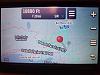
The GPS location for the bull is N40 04.359' W105 36.755' at 10,949 ft.
From the Long Lake parking lot it is 1.57 miles straight line distance, and the track is ~2.3 miles by trail. It is north and slightly east of the east end of Lake Isabelle about 1/8 mile, in a cirque/meadow east of the Pawnee Pass trail 907.
As you go up the trail heading for Lake Isabelle (and before you get to the lake) there will be a couple switchbacks. There is orange and blue flagging tape in a tree on the right, and up the draw all the way to the animal (about 300 yards). Go up, veer right, then left.
Along the trail for a mile or more are painted stakes with numbers progressing up the trail. At stake #41 is the flagging tape marking the off-trail route.

Colorado AR-15 Shooters Club Discussion Forums
Welcome to the Colorado AR-15 Shooters Club Discussion Forums.

 Reply With Quote