Link to a current chart:Originally Posted by BushMasterBoy

https://aeronav.faa.gov/visual/12-26...-Wash_Heli.pdf
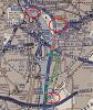
The 1000 marks in the image above are for Route 6. On the current map linked above Route 6 shows max 1400 on either side to the east and west of the airport with a 1500ft lane over the top of the airport. The way you read these is a line on the botom of the number in a minimum altitude, a number with line on top and bottom is the recommended altitude, number with line on top is the maximum altitude. Blue line through the route is altitude change point, blue triangle is a compulsory reporting point.
Route 1 to the northwest of the airport and Route 4 which the helo was flying has a max 200 altitude and they are to hug the east bank of the river. You can see that where Route 4 turns to Route 1 it takes the east channel of the river to the northeast of the airport in order to give the airport a wider berth. The impact point was in line (southeast of the airport) with the end of the runway where the text "Boiling" is so further south than what you have marked.
Green airplane route, red helo route, where arrows meet is impact site.

Colorado AR-15 Shooters Club Discussion Forums
Welcome to the Colorado AR-15 Shooters Club Discussion Forums.

 Reply With Quote